![](/images/other/stat-length.png)
![Randonnée V.T.T. Val de Briey - Boucle Mancieulles boisée - Photo](https://media.geolcdn.com/t/1900/400/ext.pjpeg?maxdim=2&url=https%3A%2F%2Fstatic1.geolcdn.com%2Fsiteimages%2Fupload%2Ffiles%2F1524743154velo.jpg)
Boucle Mancieulles boisée
mendez54
Utilisateur
![Longueur](/images/other/stat-length.png)
Longueur
38 km
![Altitude max](https://static1.geolcdn.com/siteimages/upload/files/1508320355ic_sort_altitude_max_24dp.png)
Altitude max
319 m
![Dénivelé positif](https://static1.geolcdn.com/siteimages/upload/files/1508320355ic_sort_den_pos_24dp.png)
Dénivelé positif
518 m
![Km-Effort](/images/other/stat-length.png)
Km-Effort
45 km
![Altitude min](https://static1.geolcdn.com/siteimages/upload/files/1508320355ic_sort_altitude_min_24dp.png)
Altitude min
222 m
![Dénivelé négatif](https://static1.geolcdn.com/siteimages/upload/files/1508320355ic_sort_den_neg_24dp.png)
Dénivelé négatif
521 m
![Boucle](https://static1.geolcdn.com/siteimages/upload/files/16400158638029165_repeat_loop_refresh_sync_direction_icon.png)
Boucle
Oui
Date de création :
2017-07-18 00:00:00.0
Dernière modification :
2017-07-18 00:00:00.0
![V.T.T.](https://static1.geolcdn.com/sitytour/trail-icons/202.png)
2h55
Difficulté : Moyen
![Scannez ce code QR pour ouvrir la randonnée dans l'application SityTrail](https://capi.geolives.com/qq0zvz2zws4bq2lad0pu/sitytour/trails/791661/qr.png?size=200)
Application GPS de randonnée GRATUITE
À propos
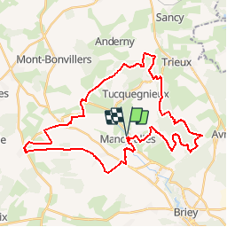
Randonnée V.T.T. de 38 km à découvrir à Grand Est, Meurthe-et-Moselle, Val de Briey. Cette randonnée est proposée par mendez54.
Description
Départ Mancieulles - Bois d'Avril - Bois de Bettainvillers - Tucqugnieux - Bois d'Anderny - Mairy - Mainville - Anoux - Mancieulles
Localisation
Pays :
France
Région :
Grand Est
Département/Province :
Meurthe-et-Moselle
Commune :
Val de Briey
Localité :
Unknown
Départ:(Dec)
Départ:(UTM)
710303 ; 5463308 (31U) N.
Commentaires
Randonnées à proximité
![Randonnée A pied Val de Briey - CV Haut Charme - Photo](https://media.geolcdn.com/t/375/260/4e9bdffd-7a79-4a02-9ca5-caf611bbbb83.jpeg&format=jpg&maxdim=2)
![A pied A pied](https://static1.geolcdn.com/sitytour/trail-icons/100.png)
CV Haut Charme
A pied
Facile
Val de Briey,
Grand Est,
Meurthe-et-Moselle,
France
![](/images/other/stat-length.png)
11,1 km | 13,8 km-effort
3h 8min
![](https://static1.geolcdn.com/siteimages/upload/files/16400158638029165_repeat_loop_refresh_sync_direction_icon.png)
Oui
![Randonnée Marche Val de Briey - Briey en famille - Photo](https://media.geolcdn.com/t/375/260/7a2bae71-a77e-4de9-b61c-c53dacb17e80.jpg&format=jpg&maxdim=2)
![Marche Marche](https://static1.geolcdn.com/sitytour/trail-icons/101.png)
Briey en famille
Marche
Facile
Val de Briey,
Grand Est,
Meurthe-et-Moselle,
France
![](/images/other/stat-length.png)
8,1 km | 10,3 km-effort
2h 21min
![](https://static1.geolcdn.com/siteimages/upload/files/16400158638029165_repeat_loop_refresh_sync_direction_icon.png)
Oui
![Randonnée Randonnée équestre Val de Briey - Briey 1 - Photo](https://media.geolcdn.com/t/375/260/ext.jpg?maxdim=2&url=https%3A%2F%2Fstatic1.geolcdn.com%2Fsiteimages%2Fupload%2Ffiles%2F1524743154cheval.jpg)
![Randonnée équestre Randonnée équestre](https://static1.geolcdn.com/sitytour/trail-icons/301.png)
Briey 1
Randonnée équestre
Facile
Val de Briey,
Grand Est,
Meurthe-et-Moselle,
France
![](/images/other/stat-length.png)
9,2 km | 10,5 km-effort
1h 53min
![](https://static1.geolcdn.com/siteimages/upload/files/16400158638029165_repeat_loop_refresh_sync_direction_icon.png)
Non
![Randonnée A pied Val de Briey - Boucle de Mance - Photo](https://media.geolcdn.com/t/375/260/ext.jpg?maxdim=2&url=https%3A%2F%2Fstatic1.geolcdn.com%2Fsiteimages%2Fupload%2Ffiles%2F1545311037marcheuse_200dpi.jpg)
![A pied A pied](https://static1.geolcdn.com/sitytour/trail-icons/100.png)
Boucle de Mance
A pied
Facile
Val de Briey,
Grand Est,
Meurthe-et-Moselle,
France
![](/images/other/stat-length.png)
10 km | 12,2 km-effort
2h 46min
![](https://static1.geolcdn.com/siteimages/upload/files/16400158638029165_repeat_loop_refresh_sync_direction_icon.png)
Oui
![Randonnée Course à pied Val de Briey - run matinal - Photo](https://media.geolcdn.com/t/375/260/ext.jpg?maxdim=2&url=https%3A%2F%2Fstatic1.geolcdn.com%2Fsiteimages%2Fupload%2Ffiles%2F1524743154running.jpg)
![Course à pied Course à pied](https://static1.geolcdn.com/sitytour/trail-icons/103.png)
run matinal
Course à pied
Facile
Val de Briey,
Grand Est,
Meurthe-et-Moselle,
France
![](/images/other/stat-length.png)
10,1 km | 13,6 km-effort
55min
![](https://static1.geolcdn.com/siteimages/upload/files/16400158638029165_repeat_loop_refresh_sync_direction_icon.png)
Oui
![Randonnée Marche Val de Briey - Phil - Photo](https://media.geolcdn.com/t/375/260/ext.jpg?maxdim=2&url=https%3A%2F%2Fstatic1.geolcdn.com%2Fsiteimages%2Fupload%2Ffiles%2F1553511878bg_sport_marche.png)
![Marche Marche](https://static1.geolcdn.com/sitytour/trail-icons/101.png)
Phil
Marche
Facile
Val de Briey,
Grand Est,
Meurthe-et-Moselle,
France
![](/images/other/stat-length.png)
11,8 km | 15,4 km-effort
2h 19min
![](https://static1.geolcdn.com/siteimages/upload/files/16400158638029165_repeat_loop_refresh_sync_direction_icon.png)
Non
![Randonnée Vélo de route Lubey - Tour lubey ozeraille - Photo](https://media.geolcdn.com/t/375/260/ext.jpg?maxdim=2&url=https%3A%2F%2Fstatic1.geolcdn.com%2Fsiteimages%2Fupload%2Ffiles%2F1524743154velo.jpg)
![Vélo de route Vélo de route](https://static1.geolcdn.com/sitytour/trail-icons/201.png)
Tour lubey ozeraille
Vélo de route
Moyen
Lubey,
Grand Est,
Meurthe-et-Moselle,
France
![](/images/other/stat-length.png)
12,9 km | 14,5 km-effort
46min
![](https://static1.geolcdn.com/siteimages/upload/files/16400158638029165_repeat_loop_refresh_sync_direction_icon.png)
Non
![Randonnée Marche Trieux - trieux - Photo](https://media.geolcdn.com/t/375/260/ext.jpg?maxdim=2&url=https%3A%2F%2Fstatic1.geolcdn.com%2Fsiteimages%2Fupload%2Ffiles%2F1553511878bg_sport_marche.png)
![Marche Marche](https://static1.geolcdn.com/sitytour/trail-icons/101.png)
trieux
Marche
Très facile
Trieux,
Grand Est,
Meurthe-et-Moselle,
France
![](/images/other/stat-length.png)
3,2 km | 3,7 km-effort
1h 0min
![](https://static1.geolcdn.com/siteimages/upload/files/16400158638029165_repeat_loop_refresh_sync_direction_icon.png)
Non
![Randonnée V.T.T. Val de Briey - Boucle mancieulles cote briey avril - Photo](https://media.geolcdn.com/t/375/260/ext.jpg?maxdim=2&url=https%3A%2F%2Fstatic1.geolcdn.com%2Fsiteimages%2Fupload%2Ffiles%2F1524743154velo.jpg)
![V.T.T. V.T.T.](https://static1.geolcdn.com/sitytour/trail-icons/202.png)
Boucle mancieulles cote briey avril
V.T.T.
Moyen
Val de Briey,
Grand Est,
Meurthe-et-Moselle,
France
![](/images/other/stat-length.png)
26 km | 31 km-effort
1h 40min
![](https://static1.geolcdn.com/siteimages/upload/files/16400158638029165_repeat_loop_refresh_sync_direction_icon.png)
Oui